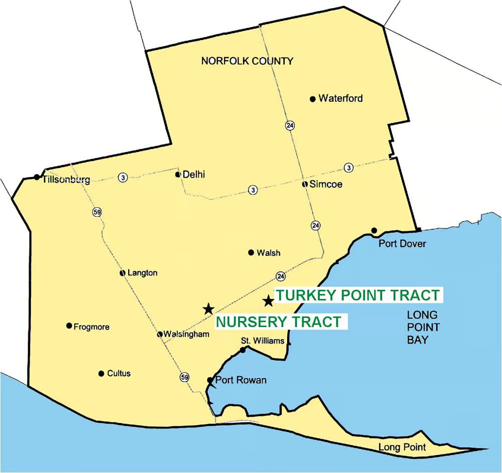
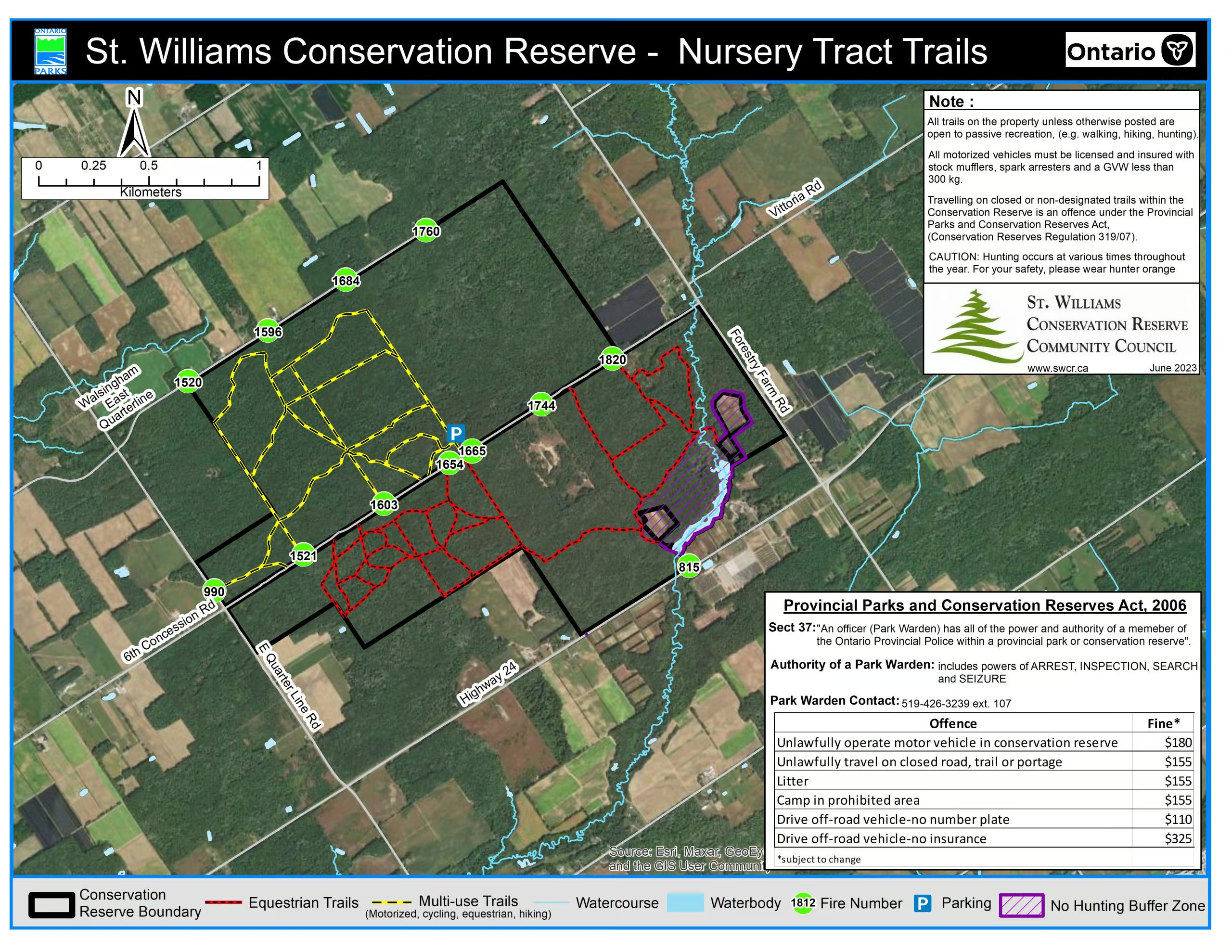
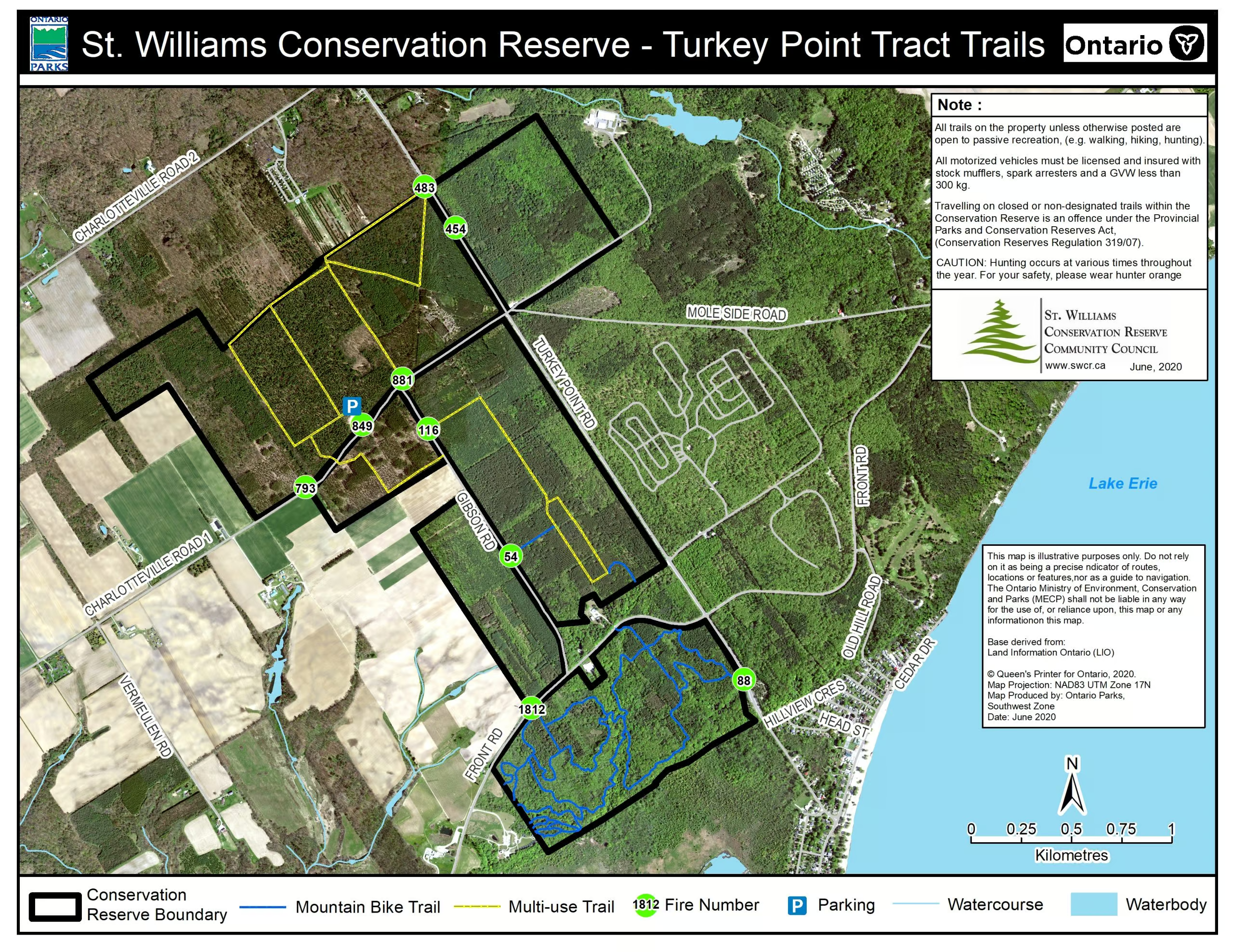
Skip to content
Saturday, July 02, 2022

St. Williams Conservation Reserve

Rebuilding vital ecosystems to honour Ontario’s heritage

  • About the CR
    • Welcome
    • Our goals
    • Operations Plan
    • Opportunities for Public Input
    • History
    • Gallery
  • News & Events
    • Volunteer events
  • Blog
  • Community Council
    • Join the SWCRCC
    • Member’s page
  • Conservation
    • Species at Risk
    • Research
  • Recreation
    • Permitted Activities
    • Maps
    • Code of Conduct
    • Trail density info
  • Contact Us
    • Get Involved
    • Opportunities for Public Input
    • Links
About the SWCR

Maps

St. Williams Conservation Reserve Trail Maps:

Property locations mapClick the links below to download high resolution trail maps for the SWCR properties:

Trail Map – St. Williams Nursery Tract

Trail Map – Turkey Point Tract


facebookShare on Facebook
TwitterTweet
FollowFollow us

Related Articles

About the SWCR

The Community Council

Posted on April 25, 2014September 5, 2019 Author swcrcc

The Saint Williams Conservation Reserve Community Council is a diverse and committed group of volunteer board members. Our members bring a range of skills, experience and perspectives to the Council, and meet regularly to attend to the governance, management and strategic direction of the Reserve and Council. Council committees include Trails and Recreation, Vegetation Management […]

About the SWCR

History

Posted on September 4, 2010November 11, 2017 Author admin

From Forest to Desert Our pioneer forefathers were faced with deeply forested, impenetrable bush when they arrived in this area. By law they had to clear their free land and farm it.  Without plant or forest cover, however, the sandy topsoil of this region blew away in the wind. Within 50 years parts of Norfolk […]

About the SWCR

Conservation Actions

Posted on November 7, 2017November 9, 2017 Author swcrcc

The vision for the Reserve is to restore the native ecosystems that existed here more than 200 years ago. We actively manage the ecological communities on the reserve to achieve this goal. All of our practices are based on sound research, expert consultation, and the best management practices available. Click on the management activities below […]

Post navigation

Habitat selection of Eastern Hognose snakes in southwestern Ontario
Applications

News & Events

Trail update

Posted on May 12, 2022 Author swcrcc

Logging operation update!

Posted on March 26, 2022 Author swcrcc

New Wayfinding Signage at the CR

Posted on January 19, 2022January 19, 2022 Author swcrcc

Posted on September 25, 2021September 25, 2021 Author swcrcc

Facebook

St. Williams Conservation Reserve

For more stories, see our Facebook page

Volunteers

SWCR is currently recruiting new volunteers.

If you are interested in being a Community Council member please fill out an application.

Species at risk

A “species at risk” is any naturally-occurring plant or animal that is in danger of extinction or of disappearing from the province.

Learn more about species at risk.

RSS feed

Here is our RSS feed.

What is the SWCR?

The St. Williams Conservation Reserve includes 1035 hectares of Crown land in Norfolk County, Ontario. The Reserve is made up of two separate sites: the Nursery Tract and the Turkey Point Tract.

Our primary objective is to restore and enhance the native ecological communities at this site, which will benefit the many rare and threatened species that live here.

Quick Links

  • Trails brochure
  • Blog
  • Research application
  • Report sightings of Species at Risk
  • Contact Us
© 2017 St. Williams Conservation Reserve.  Site by Guardian Computing.